

Bangalore Metro Route Map: Timing, Lines, and Stations
Bangalore, officially known as Bengaluru, has transformed its urban commute with the introduction of the Namma Metro. This rapid transit system, detailed in the Bangalore Metro Route Map, offers a comprehensive solution to the city's traffic challenges.
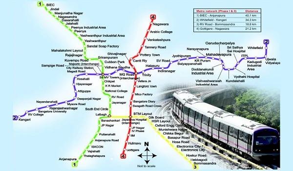
Bangalore Metro Overview
Namma Metro, translating to "Our Metro" in Kannada, began operations in 2011. It stands as India's third operational metro system, following Delhi and Kolkata. The metro network integrates elevated, underground, and at-grade sections, ensuring extensive coverage across Bengaluru. Managed by the Bangalore Metro Rail Corporation Limited (BMRCL), the system continues to expand, enhancing connectivity for residents and visitors alike.
Operational Lines and Stations
Purple Line: East to West Corridor
The Purple Line stretches from Whitefield (Kadugodi) in the east to Challaghatta in the southwest. Covering key areas like MG Road, Vidhana Soudha, and Majestic, this line serves as a vital link between residential zones and commercial hubs. With a total of 37 stations, it facilitates seamless travel across the city.
Green Line: North to South Axis
Connecting Nagasandra in the north to Silk Institute in the south, the Green Line encompasses 30 stations. It traverses significant locales such as Yeshwanthpur, Majestic, and Jayanagar, catering to both daily commuters and occasional travelers.
Upcoming Lines: Expanding the Network
-
Yellow Line: Set to connect RV Road to Bommasandra, this line will enhance access to the city's southern regions.
-
Pink Line: Linking Kalena Agrahara to Nagawara, the Pink Line will provide improved connectivity to the eastern and southern parts of Bengaluru.
-
Blue Line: Planned to run from KR Puram to Central Silkboard, this line aims to ease congestion along the Outer Ring Road corridor.
-
Orange Line: Proposed to connect JP Nagar to Hebbal, the Orange Line will facilitate north-south travel across the city.
-
Red Line: Envisioned to link Hebbal to Sarjapura, this line will serve as a crucial addition to the metro network, addressing the growing demand in these areas.
Metro Timings and Frequency
Namma Metro operates daily, ensuring convenience for all commuters:
-
Weekdays (Monday to Friday): Services commence at 5:00 AM and conclude at 12:00 AM.
-
Weekends (Saturday and Sunday): Operations run from 6:00 AM to 11:00 PM.
Train frequency varies between 4 to 15 minutes, depending on the time of day and passenger demand.
Key Interchange Stations
Certain stations serve as pivotal interchange points, allowing passengers to switch lines effortlessly:
-
Majestic: Interconnects the Purple and Green Lines.
-
Jayadeva Hospital: Facilitates transfers between the Yellow and Pink Lines.
-
RV Road: Connects the Green and Yellow Lines.
-
Nagawara: Links the Pink and Blue Lines.
Smart Travel with Namma Metro
Daily commuters and tourists benefit from smart card systems, mobile ticketing, and digital recharge options. These innovations reduce wait times and simplify the travel process. Touchless ticketing options also ensure safe and fast entry through automated fare collection gates.
The metro stations offer modern amenities such as escalators, elevators, CCTV surveillance, and clean waiting areas. These features contribute to a comfortable and secure travel environment.
Connectivity to Major Landmarks
Bangalore Metro connects several important destinations across the city. Commuters can easily access places like Kempegowda Bus Station, Kempegowda International Airport (via feeder services), Cubbon Park, Lalbagh Botanical Garden, and major business districts in Indiranagar and Whitefield.
The Purple and Green Lines serve educational institutions and healthcare centers, including Bangalore University, Christ University, and prominent hospitals. Students, healthcare workers, and patients benefit from faster, more reliable travel.
Last-Mile Connectivity Options
Feeder bus services, shared autos, ride-hailing apps, and bike taxis complement metro travel. These last-mile solutions bridge the gap between metro stations and final destinations. Metro stations offer bicycle stands and auto-rickshaw bays to encourage multimodal transport.
Namma Metro's integrated mobility plan supports reduced car dependency and promotes public transit usage. By adopting sustainable alternatives, Bengaluru continues to combat pollution and traffic congestion.
Future Developments
BMRCL continues to expand the metro network, aiming to cover more areas and reduce traffic congestion. Upcoming phases include the addition of new lines and the extension of existing ones, ensuring comprehensive coverage of Bengaluru's urban landscape.
Advanced signaling systems and driverless trains are also under consideration, ensuring higher efficiency and safety. The future of Bangalore Metro includes smart mobility solutions aligned with the city's growth trajectory.
Conclusion
The Bangalore Metro Route Map exemplifies the city's commitment to enhancing public transportation. With its expanding network, timely services, and focus on connectivity, Namma Metro stands as a testament to Bengaluru's progressive infrastructure development.
For more information or inquiries, feel free to contact us.
Frequently Asked Questions
-
What is the Bangalore Metro Route Map?
The Bangalore Metro Route Map shows all current and upcoming metro lines and stations in the city.
-
How many lines does the Bangalore Metro currently operate? N
amma Metro operates two main lines: the Purple Line and the Green Line.
-
Are new metro lines coming soon in Bangalore?
Yes, lines like Yellow, Pink, Blue, Orange, and Red are under development.
-
What are the metro timings in Bangalore?
The metro runs from early morning to late night every day, with slight variations on weekends.
-
Can I switch lines easily during my journey?
Yes, interchange stations like Majestic and Jayadeva Hospital allow easy line changes.
-
Does the Bangalore Metro connect to the airport?
While no direct metro line exists yet, feeder services connect metro stations to the airport.
-
How often do metro trains run?
Trains run frequently, with shorter intervals during peak hours and slightly longer during off-peak times.
-
Is Namma Metro safe for solo travel?
Yes, the metro offers a secure environment with CCTV, security staff, and well-lit stations.
-
Can I use digital payment for metro tickets?
Yes, commuters can use smart cards, QR code tickets, and digital wallets.
-
Are the metro stations accessible for the elderly and differently abled?
Yes, all stations provide elevators, ramps, and other facilities for easy accessibility.
